Showing posts with label layout. Show all posts

Sunday, April 12, 2015

CANBERRA, AUSTRALIA

                       Australia’s Capital
       In 1901 when all the states joined as one federation, even though each state had a capital, it was apparent that the country also needed a capital. Stiff competition developed between Sydney and Melbourne for the honor, but Canberra was chosen for its inland location, its clean air and water, for security reasons, and to put an end to the bickering between the two large cities.
    The 900 square miles of prime sheep country is in a valley known as the plains of Yass, and is about equal distance from both Melbourne and Sydney. It is known as the Australian Capital Territory or A.C.T. for short.  The Aboriginal word canberry meaning ‘meeting place’ was changed to Canberra. The city is referred to as the bush capital, city of the grey flannel suit, monument valley, or the garden city of the commonwealth----depending on the view of the speaker.  And the inhabitants say, ‘To know Canberra is to love it’.
    The city is a totally planned one. After an international competition, Walter Burley Griffin from Chicago was chosen as the architect to design the city. Griffin arrived in Canberra in 1913 to supervise construction. Two World Wars and the depression slowed progress and by 1947 Canberra still was a country town of 15,000.
    Griffin envisioned a spacious city, a city that could breathe. Development was rapid in the 1950s and the city built for 50,000 is now home to 300,000, with suburbs all around it. 
    Lake Burley Griffin was originally planned as three small lakes, but was built as one large lake with three bridges dividing it. The impression of the city is one of calm and order as well as spaciousness. The streets are wide. Because the city was built on the plains originally there were no trees. Thousands of trees have been planted every year and now the city boasts of 11-15 million trees, all planted by hand! Normal rainfall is 64 inches a year.
   Major public buildings are built on low knolls around the lake. There are no billboards. All colors are muted and generally all buildings are low. Canberra is a one company town and the government owns all the land; 65% of the city’s work force are government employees. The rest are in service industries.
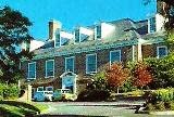
U S Embassy
    One exception to land ownership is the ten acres the US embassy sits on. Australia deeded this land to the US for its help in World War II. The Embassy is the largest and sits on the highest knoll. All of the red brick in the colonial building was imported from the United States.
    There are numerous embassies and high commissions of traditional and unusual design in this capitol city. Countries related to the Motherland have high commissions instead of embassies.
    The top of Mt. Ainslie Pat provides a fantastic view of the city and suburbs!
    The Telstar tower rises 195 meters above the summit of Black Mountain. Opened in 1980, it is a major tourist attraction, although its primary function is to provide essential communication facilities.
    The new parliament building cost the country a billion dollars to build. Opposition to tearing down the old parliament was so fierce it remains standing intact in front of the new building making a nice contrast. The new parliament is actually five buildings joined together with glass link-ways; we walked only some of the 23,000 granite slabs covering the curved areas; the hallways total 20 kilometers.
   The foyer of the parliament building with its wide curved stairways is a show place. The masonry and timber used throughout is beautiful. The 81-meter flagpole is a central landmark of the city. The great hall houses one of the world’s largest tapestries, measuring 20 x 9 meters and weighs 400 kilos. Using 360 colors it took two and a half years to complete. From a distance it appears to be an oil painting. Only on close inspection is it evident that it is truly a tapestry—a really magnificent one!
  Canberra is not high on many tourist agendas, but our time there was interesting and the visit was a worthwhile one. It is a pretty capital city without the trappings of junk-stuff so often found.

Sunday, July 20, 2014

THE PANAMA CANAL

                                 A Man-Made Wonder
 
I’m sure many of my readers have transited the Panama Canal, so this will serve as a summary and will require a couple of posts to even accomplish that.
At both the Miraflores and Gatun Locks we had to pass through metal detectors and have all bags etc scanned.  Just part of normal life these days! The Panama Canal is one of the great engineering feats of all time. The locks were designed to lift ships from sea level up 85-feet to Lake Gatun. It is amazing that 100 years later the locks are in near perfect condition. However, the canal is presently building larger locks alongside the present ones to accommodate today’s large mega ships. The new lock construction, parallel to the original locks, is due to be completed this year. The new locks will use recycled water whereas the present locks do not. Today the canal employs 9,000 workers. There are three observation towers and a visitor center at the Miraflores locks.
 Heavy rainfall and several rivers feed the lake for the canal to function. Hydro-electric power is also generated.
Forty ships a day transit the almost 50-mile long canal bringing 500 million dollars to Panama. In a year over 13,000 ships from 79 countries make the trip. The Canal saves ships 2000 miles if they had to sail around the tip of South America. Today all arrangements must be made and paid for in cash in advance of transit.
Fees are based on tonnage for laden ships and is less for ships in ballast. In the late 1800s the French Company attempted to build a canal, but disease (malaria, plague, and yellow fever), rain, mud, scandal, corruption and the loss of 16-20,000 lives eventually bankrupted the company.
Freighter passing through Miraflores Locks


The US negotiated a favorable treaty with Panama in 1903 and started construction. The geographically stable area was a big consideration for the site of the canal. In 1904 Col. William Gorges undertook the problems of sanitation and the task of eliminating mosquito breeding areas in the jungle.
Ten years later, in 1914, the canal was complete. It had taken the labor of 75,000 men to build this marvel, often referred to as one of the man-made wonders of the world.
Because of World War I the official inauguration was postponed until 1920. The United States was given control of the canal for 100 years.     
There are six locks in the canal, three on each end. They are 110-feet wide and 1050-feet long. Each lock has two chambers, side by side, so ships can go in either direction at the same time. Four and a half million cubic feet of concrete were needed for the locks and dam. The gates are seven feet thick. The drop and rise in each of the locks is 28 feet. The water drops 39-inches a minute through 18-inch culverts. All the water in the locks and lakes is fresh, fed by the mighty Chagres River and two smaller rivers.
On the Pacific end, the first two adjoining locks (or the last two if you are transiting south) are the Miraflores locks.  The original 39 mules were built by General Electric for a total cost of $528,680. The new mules built by Mitsubishi cost  $2 million dollars each.
Miraflores Lake, at the end of the second lock, is small with a yacht harbor at the north end.
The next lock, Pedro San Miguel, is a single lock. Leaving this lock one can glimpse the mouth of the Rio Grande River.
To be continued next time