Wednesday, April 18, 2012

BALKAN COFFEE CULTURE

            Interesting Culture

            Everywhere we visited throughout the Balkans we ran into the coffee culture which fascinated me.  Coffee bars line the narrow streets and alleys in every town and village. They stand side by side and are interspersed among sidewalk cafés and restaurants. Strong Turkish coffee is the only coffee available, and it is served in tiny porcelain cups which contain about two swallows. Of course it is sipped in tiny amounts. Desserts are available it the coffee bars, but no other food. Desserts are sweet, but everyone loves them.
One can sit all day long with one cup of coffee if desired. No one ever tries to hurry or rush you away. And people do sit for hours visiting or just as often by themselves. People read, work on computers or visit with friends. The coffee bars open early in the morning and remain open late at night.  No one ever seems to be in a rush.
            I found it amazing that in spite of the really tough times these people have experienced and are still living that they never had their hand out. They always seemed surprised and delighted with a tip, but it was never expected and if it was not given there was no grumbling or nasty looks. They are a kind and gracious people.

            We have our own coffee culture in the United States and it is called Starbucks. But it is quite different than that in the Balkans. First the coffee is different. And we mostly drive through or enter, get our fix and leave with disposable coffee cup in hand. In the Balkans there is no disposable coffee container and one does not walk about on the street drinking. We have a much more rush and move-on mentality where the Balkan people are relaxed. Both cultures are interesting---I am familiar with one and fascinated by the other.


Sunday, April 15, 2012

FIGHTING FOR A FLIGHT

                                            Sometimes It's Easy, Sometimes It's Not

            After one travels enough you know what flights you want and I for one am not willing to tromp all over kingdom come with multiple plane changes to get to my destination. When we went to the Balkans we were to start out in Vienna. The Vienna stay would be short and I had several things I wanted to accomplish.
Months before the trip I learned that most likely I’d be routed through Frankfort, Germany and not arrive in Vienna until 2:30 or later in the afternoon. After traveling all night that was not satisfactory! Returning home from Zagreb we were stuck with Lufthansa Airlines or one of their partners so I got on the web to see what US city had a direct United flight to Vienna. It was not a problem for me to get to any US gateway city.
            When I found a direct flight from Dulles, Washington, DC I called the tour company requesting that flight. We had quite a confrontation on the phone with my not being allowed to talk to the travel department and being informed that they did not take requests plus a lot of rhetoric about restrictions, contracts etc. I was not about to take no for an answer and informed them I would be a pest as, since it was my fourth visit to Vienna, I knew what I wanted to see in Vienna, where I wanted to go and what I wanted to buy and I did not want to waste the day flying especially after flying all night. About two and a half weeks later  I got my airline schedule in the mail which did put me on my requested flights.
            Our guide met the flight and we were actually in our hotel at 9:30 AM. Of course our rooms were not ready, so I left my luggage with the concierge, got directions to Stephenplatz and took off by myself as everyone else wanted to rest. I had until late afternoon before my travel buddy arrived from L A. I accomplished my goals and was back at the hotel about ten minutes before she arrived.
Coming home there was little chance of avoiding Frankfort, Germany so I just had to cope with that miserable airport and its disagreeable people. But coming home I didn’t care, and if the dirty laundry got lost---oh well. As it turned out we sailed through the Frankfort airport and because the security area we chose was very quiet we even chatted with a couple of friendly young security fellows. It was the easiest pass-through at Frankfort I had ever had.


Wednesday, April 11, 2012

SOMETIMES IT'S STRESSFUL

            Stress and a Great Drink

When biking along the Danube we had many interesting experiences. Ten kilometers out of Linz, Austria our guide stopped us   saying, “For the rest of the ride today you  must use extra caution. We are about to enter an elevated bike path. It is a concrete sidewalk about three feet above the street level. Traffic will be heavy and moving fast on your right and bikers going in the opposite direction will be passing on your left. Keeping your distance is very important. I caution you to be especially alert.”
It was a stressful six miles. I kept my eyes on the sidewalk and tried to ignore the vehicles whizzing by on the highway below. I would have been more comfortable if we were riding on the inside instead of the bikers going in the opposite direction. Fortunately we all made it safely with no mishaps.
Although stressed at the end of the day  I was surprised to find I was not as tired after this 40 mile day as I was on the first day to Passau. We arrived at our hotel about 5:00PM.
I was dying for a nice big glass of ice tea, something unheard of in most of Europe. After entering the hotel I went directly to the bar and asked  "May I have (buy) a cup of hot tea?”
“Yes.”
When I was handed the tea I asked, “Now, may I have the largest container you have full of ice?”
“Really?” the bar tender said as he gave me a strange look.
“Yes, please. And may I take this all up to my room? I will return everything to you when we come down to dinner.”
The bar tender was shaking his head as I walked  to the elevator.  In my room I grabbed a glass, filled it with ice and poured in the tea. Ay, the pleasure!  And that is how I got my one and only glass of ice tea on the entire trip.
I did return everything to the bar and thanked the bartender. I’m sure I was probably labeled, ‘a crazy American’ but I did not care. I was a happy biker!


Sunday, April 8, 2012

AN UNUSUAL CHURCH


                                               A Small Country Church

When biking in Germany and Austria between Melk to Krems we stopped in the small village of St. Michael to visit a rather unusual church. Our guide  told us. “This hilly area is wine country. You can see the vineyards are terraced as space is at a premium. The cemetery is very small, but 11,000 people have been buried here. In order to accommodate that many people, eventually skeletons had to be dug up to make room for more recent burials.”
            What did they do with all the old bones? In a room in the back of the church they created an altar with the old dug up skulls. It was pretty eerie. A large wire bin was full of long bones—those from the arms and legs. The whole room was really spooky.
            A docent informed us, “Many years ago churches were built as fortresses to protect the village from invaders. This church originally had five towers, but only one remains today, and the gun turret is clearly visible. Also in those days people didn’t have money to pay for services so they paid in produce, eggs, chickens, or whatever  they had. As a result this church had a nice wine cellar and two rooms to keep smoked meats cool.
            “This church in St. Michael was closed from 1784-1950. In 1950 it took the residents three years to clean up the inside of the church as birds had been nesting within for over a century and a half. You can’t  imagine what a  mess that was!  In 1965 the church was renovated. The alter came from another church and is really too big for this small church. Only a few church services are held each year, but many weddings and concerts are held here.”
            An interesting if spooky visit. Not too long ago I picked up the end of a TV program that featured a similar skull room, but I missed where  it was, other than the fact that it was not the church I had visited.


Wednesday, April 4, 2012

SEA OF CORTEZ

           Islands off Mexico

The Sea of Cortez in Mexico wasn’t even on my radar until a friend called looking for a roommate and travel companion. This would be a primitive camping trip and my friend knew no one else willing to sleep on the beach in a pup tent. She figured I’d be game.
After arriving at LAX  I learned we were being weighed and limited to one small carry-on bag. I found a couple empty chairs to do a little repacking before checking in. Fortunately I’d stuck a backpack in the outside pocket of my suitcase. I pulled a change of clothes, nightgown, bathing suit, tee, mask, snorkel, and cosmetic kit out of the suitcase, put it in the pack and was good to go. In case the luggage didn’t arrive with me at least I could cope.
            On arrival in La Paz our guide told us, “The Sea of Cortez spans nine degrees of latitude crossing the Tropic of Cancer at the southernmost tip. The diverse landscape provides for a variety of cultures and ethnic groups. The shores of Baja’s Pacific coast vary from the shores along the Sea of Cortez. There are many resorts along the shores of Baja for those who enjoy that sort of comfort and travel, but the 53 uninhabited islands and the many rock outcroppings in the Sea of Cortez provide adventure and real variety. We will be camping on Isla Espiritu Santo, one of the larger islands in the southern part of the Sea."
            Espiritu Santo is approximately 25 miles from La Paz and a 2 ½ hour boat ride. When arriving at our beach the azure blue, clear water was too shallow for the boat to get very close to shore, so the captain dropped an anchor over the side and we loaded pangas (small outboard Zodiac-type motor boats) for the trip into the beach. The 6 X 8 tents housed two people. You can imagine the calisthenics we performed when getting out of a wet bathing suit!
            We retired early after the evening programs, but the gentle lapping of the waves on the beach soon sent me off to dreamland. I woke with the sun and each morning my friend heard me say, “What a treat to wake up to fresh steaming coffee and a hot breakfast. This is the life!”
            Our cook produced wonderful meals. Food always tastes better when eaten out doors, especially when it is prepared for you! The island was our home port for ten days and we had a wonderful time with lots of adventures.

Sunday, April 1, 2012

LOVELY MOUNTAIN ACCOMMODATION

                                                Inland Belize

           After our dolphin project on the Belize atoll I decided to stay over  on the mainland to see some Mayan ruins. We traveled about 20 miles on paved road through the rural countryside. Although the road was paved it had no dividing lines, and there was very little traffic after the first five miles.
            Then we turned onto a dirt road for about another 20 miles. Our four wheel van progressed slowly dodging ruts and holes in the road. It was also a gentle climb to about 2000 feet. In the valley we passed huge citrus farms. The pine trees were tall and straight, slightly smaller than a telephone pole.
During the ride the driver told us, “The Mountain Pine Ridge here  in the southwestern part of Belize has some of the most diverse scenery in the country. These stately pines cover 300 square miles of steep hillsides in the foothills of the Mayan Mountains. Along the edges of the pine ridge are limestone caves, white water rivers, hardwood forest, and sharp escarpments with sweeping views. The climate is slightly cooler than the rest of Belize. Birds are plentiful, butterflies are particularly numerous, and there are many varieties of unusual bromeliads and other epiphytes. Much of the wilderness is in virgin condition, just as it probably was 2000 years ago when the Mayans left their footpaths.”
We were headed to Blancanceaux Lodge which happened to be owned by Frank Cuppola. The beautiful tropical landscaping was a surprise. We stayed in a lovely thatched roof cabana with a nice screened veranda that afforded us a spectacular view of a waterfall in the Privassion River beyond. All the electricity for the lodge was generated from a small facility on the river.
I spent the afternoon hiking around the area and enjoying the lovely landscaping. It was a quiet, peaceful afternoon.
The rainy season normally starts the end of May but that year the archaeologists left the area in mid-May, two weeks earlier than usual. This was not a good sign! 
 That night I fell asleep listening to the running water of the river behind our cabana not knowing if we would make it to the ruins in the morning. Would the weather let us attempt the trip? (Yes , we woke to a thumbs up, but more about that later.)

Wednesday, March 28, 2012

Galapagos islands


Tower Island and the Birds

Tower Island in the Galapagos is nick-named the Islands of Birds or Bird Island for the millions of birds who call it home. We were lucky, as it was mating season for the masked boobies, blue footed boobies, and frigate birds.
We spent a great deal of time watching the frigate birds as their mating ritual is quite spectacular. The male inflates a pouch below his neck which looks like a huge red valentine to attract his mate. The female can sometimes be pretty choosy and dance around the male for some time before deciding this is the love of her life. After watching one couple for some time, when I left the female still hadn’t made up her mind but she was warming up a bit.
We hiked up Phillips Steps to a plateau. It was a fairly rugged climb and I was glad I was  in pretty good shape. The terrain on the top was rocky.
Boobies were mating all over the area. In addition storm petrels and swallow tail gulls were flying about. Boobies have an intricate mating ritual and they are a lot of fun to watch.
It’s interesting how certain animals inhabit certain islands in the Galapagos. That is nice for the visitor as one can concentrate on one or two animals at a time and not all of them at once. It was a new adventure, island and different animals each day. It was a fabulous trip!
 
Floreana no doubt was named because of its abundant flora. As we hiked, our guide  told us, “Interestingly enough you’ll notice all the flowers on the island are either white or yellow.  That is because only one variety of bee does all the pollinating.”
We hiked a sandy path through lush vegetation. Our destination was a brackish lagoon, home to over a 1000 flamingos. We were told, “You’ll notice all the birds are on the far side of the lagoon away from any trespassers. They don’t like anything taller than they are so you need to squat while you watch them.”    We spent a considerable time watching them.
Leaving the lagoon we hiked over some rather rough terrain to Flour Beach. It was flour
not flower. Why? The beach was a fine white powder-like sand. The beach is appropriately named. The snow white sand was quite a contrast to the brown sandy beach we landed on, yet we were on the same island. A turtle breeding ground,.prevented us from swimming at that beach.   The beach was also home to thousands of hermit crabs. It was fun to watch the little crabs scamper about and then disappear into a hole.

We went ashore at Post Office Bay. Years ago sailors would leave addressed letters in a mailbox there. They also would remove any letters addressed to their destination. When they arrived in port they would stamp and mail the letters they had taken. The custom continues today. We were encouraged to take any letters  addressed to our home town to mail them on our return home.
Every day in the Galapagos was a new adventure and each day seemed to be better than the day before. It is an unusual place and a unique vacation spot--real eco-tourism!

Sunday, March 25, 2012

ELEPHANT RESEARCH CENTER

                             All About Elephants 

While in Amboseli we visited the Elephant Research Center one afternoon. In 1972 Cynthia Moss established the Center to do the most comprehensive study of elephants ever done.
            Her palm tree oasis included four sleeping tents, a dining tent, kitchen, shower, and outhouse. Two maintenance men and three research aids were employed as full time residents in this oasis. Ms. Moss continues to head up the program.
            During a lecture an aide told us, “Droughts in 1976 and 1984 killed many elephants. The reserve now has a population of 830 identified and named elephants. About fifteen elephant babies are born each year.
            “At birth a baby weighs on average 260 pounds and stands three feet tall. The gestation period is 22 months. A baby elephant is born with two sets of teeth. Over its lifetime the elephant has several sets of teeth, the sixth set coming in at about age 40 will last 20-25 years. Eventually when the elephant can no longer eat he dies and his average life span is 60-65 years.”
            Male elephants mature at about 14 years and at that point he leaves the family. Tusks appear at about 2-2 ½ years. A family is led by the matriarch of the herd, not by a male as is mistakenly and commonly believed. Males socialize together. Babies stay with the mother. When you see a lone elephant it is usually a young male who has left the family and who has not yet linked up with others.
            A female elephant goes into estrus (fertile) only 4-6 days every four years! A male comes into musth once a year and not all males are in musth at the same time. However, a male may be sexually active even at times when he is not is musth. He is fertile when in musth and the time is definitely marked as he dribbles urine and secretes a smelly fluid from a gland behind the ear. The body hormone changes also gives him a distinctive walk.
            Adult elephants eat 300 pounds of food a day often traveling 20 Kilometers (12 miles).  An adult male weighs 12,000 pounds; a female half of that. Elephants walk in a straight line like playing follow the leader, as many animals do, especially when migrating. Their paths across the plains are 12-14 inches wide. Sometimes people think these paths are tire tracks.
I said to my son, “When you think of the size of these animals it is amazing they leave such a small track/ path.”
This was an interesting visit and I certainly learned a lot about elephants I did not know.

Wednesday, March 21, 2012

BAMBERG, GERMANY


BAMBERG, GERMANY

Bamberg, Germany dates back to 973 and the whole city is  a UNESCO World Heritage Site, which is rather unusual.   Because Bamberg had no industry the city escaped bombing in W W II, and as a result Bamberg has 2000 historical buildings and monuments.
Bamberg was the center of the Franconia before 1800. A university town with 8000 students, it is often  referred to as the town of seven hills or as the Rome of the North. The city is located at the confluence of the Regnitz River and the Danube Canal, which was completed in 1992. The canal has helped tremendously to control flooding.
The city became part of Bavaria in 1802 but being located in upper Franconia the people refer to themselves as Franconians rather than Bavarians, and feel connected to Bavaria only administratively. Today the city does have an industry that produces spark plugs and fuel injection systems.
The town was ruled by bishops for 800 years. One of the highlights of the city is the rather unusual city hall situated on an island in the Regnitz River between two sections of the city. Way back in the 7th century one side of the river was for bishops, the other side for merchants. By locating the city hall in the middle of the river with a bridge on each side, it solved the problem of neutrality. The foundation of the building is shaped like a ship’s bow as it faces small falls just a few meters upstream. The tower was destroyed in 1440 when it was full of explosives and caught fire.
I was quite intrigued with city hall both for its structure and its location. However, the gorgeous frescos on the side of the building took my breath away. The frescos on the outside of the building date to the 18th century and are in unbelievable condition. In 1002 the German King, Henry II, chose Bamberg as his residence.
Bamberg with its cobbled streets and wonderful old buildings is a quaint and picturesque town, really little more of a small village.

Sunday, March 18, 2012

ISLAS FLOTANTES

                   Floaring Islands of Peru 

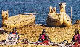
The major attraction in Puno, Peru is the Uros people and their Floating Islands. Even though it is a bit over commercialized, it is popular because it is different from anything else in the world. The floating islands are 5-15 miles off shore. 
Because of intermarriage with Aymara-speaking Indians, there are no pure blooded Uros left. The original language is lost and they now speak Aymara. Always a small tribe, the Uros began their unusual floating existence centuries ago when they desired to isolate themselves from the Collas and Incas. There are only 160 people living on the islands today, with 1600 more living in Puno. The attractions of shore life beckon to the young.
Heavy rains years ago caused some arthritic-like problems among the Uros people. Today they arrive on their floating islands early morning with their wares and leave for Puno about 4:00 PM. It is a very commercial venture now, but a very different life style. Only 3-4 people actually stay on the islands at night. Living on a floating island has its advantages. When the family gets too large or if there are disagreements in a village, a section of the island is sawed off and it floats away.  Thus, the number of islands varies, but there are generally between 40 and 50 at any given time. The blue of the lake waters contrasted vividly with the golden color of the reeds.
The lives of the Uros are totally interwoven with the totora reeds growing in the shallow waters of Lake Titicaca. The floating islands are made of many layers of reeds. As the reeds on the bottom rot, new reeds are added to the top layer, so the islands are a bit soft and spongy.  It was a strange feeling to walk on the islands which I liken to walking on a water-bed. The biggest of the islands contains several buildings including a school. Another island had a small one-room museum.
   The totora reeds are also used to build canoe–type boats. These boats will last a family about six months for transportation and fishing. We rode in one of these boats from one island to another. Much like a canoe, we all sat very still during the passage, as the water was cold and none of us wanted to land in it. I’m sure the boats are more stable than we thought. These boats have been built since 1445 and are really an art form.
The reeds have many uses on the islands. Besides the skillfully woven boats, they are the main building material for the homes. Even food is created from the pith of the reeds, which makes a nourishing asparagus-like vegetable. Some of the pith is also dried and turned into flour, for baking bread.
          Commercial fishermen have over-fished the waters, tourists are affecting their traditional culture and sewage from Puno is causing environmental and health problems. Sewage and pesticides are causing sickness as well as affecting the totora reeds that aren’t growing to the lengths they once did.
            Only time will tell how the Uros people meet the modern challenges that affect their unique lifestyle. 

Wednesday, March 14, 2012

L’ANSE AUX MEADOWS

        A North American  Viking Settlement 

At the tip of the Great Northern Peninsula of the island of Newfoundland lies L’Anse aux Meadows, site of the first European settlement in North America nearly 1000 years ago. It  is a significant archeological find. Excavated remains of an 11th century Viking settlement consisting of timber-framed turf buildings (houses, workshops, etc.) that are identical of the same time period with those found in Norse Greenland and Iceland.
Viewing the outlines of Norse encampments at the UNESCO site stimulates the imagination while replicas of Norse sod buildings provide the stage for costumed interpreters to help one imagine what life in the harsh environment was like centuries ago.
            Our young Parks Canada guide told us, “Dr. Ingstad, a Norwegian, spent half his lifetime finding and working on this site, which he discovered in 1960. Unexpectedly a local fisherman told him about this place when the doctor asked if there were any strange or unusual earth formations around.”
            Walking on damp grass through the site, when asked our guide responded, “Only about 12-15 inches of wall was found. The weather had destroyed the upper parts of the wall. To preserve what is left the walls are covered with dirt which now is covered with grass.”
            The sail was the most important part of the Viking ship because it was made of wool and it took the wool of 90 sheep and many men working three years to make one.
            A building measuring 70 X 55 feet contained 5-6 rooms and fireplaces. Upper and lower walls were found. Lumps of slag iron found in several houses and large flat-surfaced stones near the river indicate the existence of a smithy. A large pit of charred wood, needed for smithy operations, was found in another pit. A tiny stone wheel carved from soapstone served as a fly-wheel on a spinning spindle  indicating that women were included in the settlement. The importance of L’Anse-aux-Meadows lies in the fact that it is the only place where actual evidence has been found that withstands scientific scrutiny that Vikings actually settled in North America. This permanent settlement took place 500 years before Columbus’s voyages.
            When we moved on to the sod buildings I was amazed at how comfortable they were inside. In the main building a “Viking” was playing a stringed instrument in front of a fire. The house was very warm and cozy---a great contrast to the drizzly cold outside.
Considerably different from later preserved settlements such as Williamsburg, it was a most interesting visit but the day was long with a lot of time spent on a bus. I’m not sure  there is a viable alternative though.

Sunday, March 11, 2012

AUTHENTIC MAORI VILLAGE

                              Interesting Visit 

On the outskirts of Rotorua we stopped at a small Anglican church along the bay. On the wall facing the water is a stain glass window of Jesus. When the waves in the bay are just right and you look out the window it appears that Jesus is walking on the water. It’s pretty fantastic!
Rotorua isn’t very big and after getting our bearings we had no trouble getting around. Walking about town we saw several small steam vents. In a small park we saw a hobo cooking his dinner just like in the old days—steaming it over the vent. Rhododendrons that grew like small trees  lined the main street and were  in glorious bloom . They were simply gorgeous!
 In Rotorua our hotel bordered on a massive thermal area known as Whakarewarewa, one of the most accessible thermal areas in New Zealand.  Whakarewarewa is called Whaka by the local people and is pronounced Faka. In Maori the wh is pronounced f. This thermal area is one of the most extraordinary sights in the country.
Everywhere you turn the earth bubbles, boils, and spits. The hydrogen sulfide order of rotten eggs hangs in the air. Whaka gives one an extensive insight into  Maori culture. Our local guide informed us that the many paths wind around bubbling mud holes and steam vents cautioning us not to stray off the paths.
            The Maori cook in a natural steam oven called a hangi. Strategically placed, the Maori never need worry about building a fire, they have steam twenty-four hours a day. Pipes carry water from the cooking pots via gravity flow to bath tubs. The water is always crystal clear. The tubs are filled each morning so that by evening the water has cooled enough for bathing. The tubs are emptied each night and scrubbed  clean.
            As we walked along, the guide told us, “There was a large volcanic eruption in 1886 which wiped out three tribes. The few people to survive made their way here so the inhabitants of this village are descendants of the survivors of that eruption. Pa is the name for a walled village that is always high on a hill with a lookout tower.”
A geyser   called  Pohutu, meaning ‘big splash’, shoots 80 feet of water into the air and it was most accommodating to perform while we were in the area.         
The guide said, “The cemetery of this village is above ground as one finds himself in very hot water if you dig very far into the ground. Each of the seven Maori tribes also has a sacred hill cemetery. Why seven tribes? Well, there is one for each canoe that sailed from Hawaii many years ago. These people called this place Aotearoa, meaning ‘land of long white cloud’, which is what New Zealand looks like on the horizon. The Maori are one race, but there are traditional  differences between the tribes regarding language, ritual, arts, crafts, and protocol.”
            The totara tree was traditionally used to make dug out canoes. Termites do not bother this wood. Today many wood carvings are made from totara.
Before exiting the village we walked through the ‘dark pavilion’ where we could see another kiwi bird in its natural environment and learn a little more about this national bird. The guide continued, “The kiwi is seldom seen in the wild.  It hunts by smell, not by sight. Its nostrils are located at the tip of its long curved beak. Technically this makes his beak the shortest of any bird, as a beak is measured from the nostrils to the tip. The kiwi has no wings so cannot fly. He is all fur and feathers over a very small skeleton. He lays the largest egg for his body weight and it is the male who incubates the egg for 80 days.”
I’ve always been fascinated with Maori culture, loved Rotorua and was thrilled to visit an authentic active Maori village.