Showing posts with label Lake Titicaca. Show all posts

Sunday, January 6, 2019

LAKE TITICACA


                                             A High Altitude City
  Puno, located on the Andean plateau is dominated by Lake Titicaca, sacred place of the Incas and home to natural and artificial islands. Titi means puma and caca means stone.   The Incas thought Lake Titicaca was shaped somewhat like a puma, but after looking at a map, I thought that took a lot of imagination. The highest navigable lake in the world is 100 miles long and covers 3200 square miles. The depth ranges from 15-20 to 900-feet deep with the northern end of the lake  the deepest. The altitude and hot sun cause a tremendous amount of evaporation.  Titicaca, located between Peru and Bolivia, is the largest lake in South America.
     Spanish founded Puno in 1668 because of its closeness to the colonial silver mine of Laykakota. The altitude is 12,565-feet above sea level and the greater  area population is 102,800. Its inhabitants are proud of their Quechua and Aymara past. Many inhabitants, especially women, daily wear colorful traditional dress
    Puno is a small port city where the main industry is tourism.  Agriculture and cattle raising are important and the area is well known for its herds of llamas and alpacas. The main crops are potato, quinoa  and other tubers, but limited access to fertilizers and seeds means low yields allowing only for subsistence farming.
    Smoke from unvented fires wafts through Puno’s streets, along with edgy waves of traffic with constant  honking horns including taxis and three-wheeled cycles that urge pedestrians to the narrow slivers of sidewalks. It is not a pedestrian friendly city.  Puno’s churches are characterized by their distinctive colonial architecture. Several plazas provide shops and restaurants.
    Rural population struggles with poverty where surviving is the main priority, illiteracy is high at 22% and higher among females than males. Health and malnutrition are related to extreme poverty, lack of clean water and sanitation infrastructure..
    The big attraction for tourists visiting Puno is the Eros people and their floating islands which were once their homes. More about them on another day

Sunday, November 15, 2015

PUNO, PERU

                                A High Altitude City

         Puno, located at the southeastern highlands on the shores of Lake Titicaca, turned out to be a rather uninteresting town, although the population is 80,000. The business part of the city is on level ground, albeit at 12,500-feet. The residential areas run up the hillsides all the way around the town. Puno, capitol of the province of the same name, is folklore capitol of Peru. Inhabitants call themselves children of the sacred lake.
     Titi means puma, and caca means stone. The Incas thought the lake was shaped somewhat like a puma. Lake Titicaca, located between Peru and Bolivia is the largest lake in South America, and the world, over 2000-meters (6500’). Needless to say the air is clear, and the lake water is a deep blue. The sunlight shining on the altiplano is luminescent, and the horizon seems endless.
      Puno, the major port on the Peru side of the lake, was founded in 1668 near the now defunct silver mine called Layakota. Except for the cathedral, there are few colonial buildings. The sun is very strong by day, and nights are very cold.
At the waterfront we boarded a small boat to get out to the floating islands. There were 8 life jackets, and 12 of us. But that was no concern to anyone, the driver just gave out the 8 jackets and then quit. On the way back we never even saw a lifejacket! Rules are a little lax at this altitude.
We slowly motored through a lot a bright green algae, and through a cut in the reeds on the calm mirror-like lake to the pickup point for the guide.
The major attraction in Puno is the Uros people and their Floating Islands which are 5-15 miles off shore. Even though it is a bit over commercialized, it is popular because it is different from anything else in the world.
Because of intermarriage with Aymara-speaking Indians, there are no pure blooded Uros left. The original language is lost and they now speak Aymara. Always a small tribe, the Uros began their unusual floating existence centuries ago to isolate themselves from the Collas and Incas. There are only 160 people living on the islands today, with 1600 more living in Puno. The attractions of shore life beckons the young.   
      Heavy rains caused some arthritic-like problems, so now the Uros people arrive on the islands early morning with their wares and leave for Puno about 4:00 PM. It is all a commercial venture, but a very different life style. Only 3-4 people actually stay on the islands at night.
The lives of the Uros are totally interwoven with the totora reeds that grow in the shallow waters of Lake Titicaca. The floating islands are made of many layers of reeds. As the reeds on the bottom rot, new reeds are added to the top layer, so the islands are a bit soft and spongy.  Walking on the islands was sort of like walking on a waterbed. The biggest of the islands contains several buildings including a school. Another island had a small one-room museum.
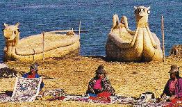
       The totora reeds are also used to build a canoe–type boat. These picturesque boats last a family about six months for transportation and fishing. We rode in one of the boats between two islands. I’m sure the boats are more stable than we thought, but tippy like a canoe, we sat very still during the passage, as none of us wanted to land in the cold water. These boats have been built since 1445.
      It was an interesting day with new adventures and insight to a very different culture.


See posts Jan 25,2012 Taquile Island  & Aug 19  2012 Puno.


Sunday, August 19, 2012

PERU AND LAKE TITICACA

PUNO  and LAKE TITICACA

 When my son and I decided to hike into Machu Picchu he said, "If we're going to be that close I'd like to continue on to Lake Titicaca." At the time I could find no American company that included Puno on their itineraries, so I booked through a Canadian company. Today, a decade later, I know of at least three American companies that include that area.
Puno in southeastern Peru is the jumping off point for Lake Titicaca, especially for the Uros people. Although quite small it is the largest city in the Puno Region. It is located at 12,421 feet above sea level at the southern end of Lake Titicaca, the world’s highest navigable lake. It also is the largest lake in South America. It is an important agricultural and livestock area  especially for llamas and alpacas that graze the large plateaus and plains of the Peru Altiplano. The areas around the lake have been inhabited since 1300 BC. Puno was established in 1668, near the site of the now-defunct colonial silver mine of Laykakota. Few colonial buildings remain.
       The city is small and there is not a whole lot to do. There is the inevitable Plaza, a few decent restaurants, plenty of local shopping, the Church of San Pedro, often called  the Sistine Chapel of the Americas and a boardwalk at the edge of the lake. Out of town there is  the Sillustani Burial Towers where hundreds of years ago, the ancient people from the Altiplano, built a series of funeral towers to bury their kings and other important people of their regions.  The Sillustani towers are perhaps the finest and most perfect cylindrical constructions of ancient Peru, and cannot be found anywhere else in South America. There also are several archeological sites  around,  for those who interested in getting ‘out of town’ for a bit.
Both men and women knit and practice textile arts as they have done for thousands of years. This is well demonstrated on the Isla Taquile in the middle of Lake Titicaca.
We boarded a small boat for a cruise on the lake eventually reaching Taquile, 36 kilometers away. The boat had 8 life jackets, and there were 12 of us. That didn’t seem to be of any concern to the crew who just gave out the 8 jackets and then quit! On the return trip we never even saw a lifejacket.
We slowly motored through a lot of bright green algae, and through a cut in the reeds on the calm mirror-like lake to the pickup point for the guide who told us, “Titi means puma, and caca means stone.” The Incas thought the lake was shaped somewhat like a puma. Looking at the map I thought it took a bit of imagination to see that.
The lake covers over 3200 square miles, and The depth ranges from 15-20 feet deep to 900-feet deep in the northern part of the lake. The lake is a bit over 100 miles long, and. 22 rivers feed the lake. There is a tremendous amount of evaporation that takes place because of the altitude and the hot sun.
Those arriving here from sea level stand a good chance of experiencing soroche, known to us non-natives as altitude sickness.  We didn’t have any problems breathing in Puno, as I guess the trek into Machu Picchu and a visit to Cuszo had acclimatized us a bit.


Sunday, March 18, 2012

ISLAS FLOTANTES

                   Floaring Islands of Peru 

The major attraction in Puno, Peru is the Uros people and their Floating Islands. Even though it is a bit over commercialized, it is popular because it is different from anything else in the world. The floating islands are 5-15 miles off shore. 
Because of intermarriage with Aymara-speaking Indians, there are no pure blooded Uros left. The original language is lost and they now speak Aymara. Always a small tribe, the Uros began their unusual floating existence centuries ago when they desired to isolate themselves from the Collas and Incas. There are only 160 people living on the islands today, with 1600 more living in Puno. The attractions of shore life beckon to the young.
Heavy rains years ago caused some arthritic-like problems among the Uros people. Today they arrive on their floating islands early morning with their wares and leave for Puno about 4:00 PM. It is a very commercial venture now, but a very different life style. Only 3-4 people actually stay on the islands at night. Living on a floating island has its advantages. When the family gets too large or if there are disagreements in a village, a section of the island is sawed off and it floats away.  Thus, the number of islands varies, but there are generally between 40 and 50 at any given time. The blue of the lake waters contrasted vividly with the golden color of the reeds.
The lives of the Uros are totally interwoven with the totora reeds growing in the shallow waters of Lake Titicaca. The floating islands are made of many layers of reeds. As the reeds on the bottom rot, new reeds are added to the top layer, so the islands are a bit soft and spongy.  It was a strange feeling to walk on the islands which I liken to walking on a water-bed. The biggest of the islands contains several buildings including a school. Another island had a small one-room museum.
   The totora reeds are also used to build canoe–type boats. These boats will last a family about six months for transportation and fishing. We rode in one of these boats from one island to another. Much like a canoe, we all sat very still during the passage, as the water was cold and none of us wanted to land in it. I’m sure the boats are more stable than we thought. These boats have been built since 1445 and are really an art form.
The reeds have many uses on the islands. Besides the skillfully woven boats, they are the main building material for the homes. Even food is created from the pith of the reeds, which makes a nourishing asparagus-like vegetable. Some of the pith is also dried and turned into flour, for baking bread.
          Commercial fishermen have over-fished the waters, tourists are affecting their traditional culture and sewage from Puno is causing environmental and health problems. Sewage and pesticides are causing sickness as well as affecting the totora reeds that aren’t growing to the lengths they once did.
            Only time will tell how the Uros people meet the modern challenges that affect their unique lifestyle.